
Civil Engineering Services
Photogrammetric Mapping Services
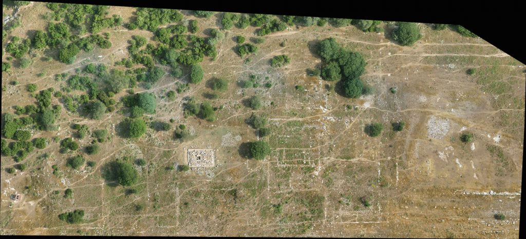
Photogrammetry comprises three separate Greek words that include ‘Photo,’ ‘Gram,’ and ‘metry,’ which means light, drawing, and measurement respectively in English. Photogrammetry gives you accurate and dependable data with measurements of physical objects from pictures to utilize them for map development, drawings, and 3D models of terrain. At Vindexa Engineerings, our skill and proficiency in Lidar technology help us to combine traditional photogrammetry with high-density point clouds for higher efficiency and more applications for difficult projects, in particular.
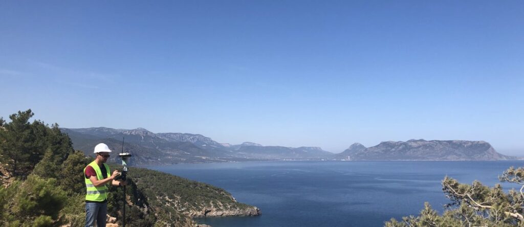
At Vindexa Engineerings, we have a team of ASPRS-certified photogrammetrists and licensed surveyors, along with highly experienced photogrammetric technicians. Our photogrammetric mapping services are known across different industries such as aerial acquisition, digital orthophotography, land administration, and transportation. We have all the information and software to meet the requirements of utility firms and also of those concerned with geological mapping.
Photogrammetric Engineering Services from Vindexa Engineerings
Our team utilizes the advanced remote sensing technique and provides various photogrammetric modeling services, including aerial photogrammetry and digital photogrammetry, among others. The various photogrammetric engineering services provided by Vindexa Engineerings include:
Aerial Photogrammetric Service
Whether taken through drones, planes, or helicopters, we can process all types of aerial photogrammetric images. Our expertise enables us to pick the best possible solution for your requirements and assess the geography of the terrain. Our sophisticated photogrammetric devices help us generate extremely high-resolution acquisitions. Our aerial photogrammetric services include aerial triangulation, DEM/DTM generation, and LIDAR data post-processing, among others.
Digital Photogrammetric Service
At Vindexa Engineerings, we provide a complete range of digital photogrammetry processing services. We undertake digital photogrammetry or image surveying to obtain precise 2D/3D-data. Our team achieves this task by using readily available or individually captured satellite images. We develop customized solutions to suit the requirements of our clients and implement them in a sophisticated manner.
Benefits of Availing Vindexa Engineerings’s Photogrammetry Services
At Vindexa Engineerings, we bring the best-in-class photogrammetric services to our global clients. Some of the key benefits that you get from our photogrammetric services are as follows:
Specialist expert GIS team: Our team of photogrammetric experts is trained to work with the latest GIS technologies and has years of experience in the field.
Precise mapping of terrain: Our photogrammetry systems can map terrain within feet of preciseness.
Visualization of terrain and 3D modeling: Our team is so skilled in 3D Modeling that it gives us complete control in the generation of planimetric features of structures. This, in turn, helps us complete the project swiftly and with absolute accuracy.
Detailed QC process: Our finished service or product is put through intense quality control procedures, thereby ensuring our customers the best quality products and services.
Construction Cost Estimation Services
Construction cost estimation helps in forecasting the cost of a building or facility that is still under construction. This will give your client a clear idea of the complete cost that will incur, right from project conception to completion. At Vindexa Engineerings we have a team of highly qualified construction cost estimators who can provide you with a precise cost estimate.
This makes it convenient to forecast the cost of your undergoing project as well as the overall management cost to be submitted to the builder. Vindexa Engineerings construction and engineering cost estimators offer comprehensive quantity takeoffs and pricing, right from conception to the final closeout.

Precise Construction Budget Estimation Services from Vindexa Engineerings
Vindexa Engineerings carefully and accurately assesses the unfolding of the entire construction process throughout its length or duration. Our construction cost consultants provide accurate construction budget estimation services to clients in the following areas:
Construction Design Estimation
At Vindexa Engineerings, we take care of screening estimation (a forecast depending on the proposed project’s capacity). We also look into preliminary estimation (made right when conceptual design decisions are made) and engineer’s estimation (based on data, specifications, and plans of already performed projects). The detailed estimation includes definitive estimates, which are generated upon completion of drawings.
Construction BID Estimation
We submit bid assistance to our clients for competitive bidding or negotiation. At Vindexa Engineerings, we provide precise, comprehensive documentation and cost estimation reports to builders, construction owners, and contractors for negotiation or bidding. Our construction bid estimation service comprises third-party quantity tabulations and quantity take-off.
Contract Cost Review
Contracts help in moving the risk to low tiered parties as a part of several risk management strategies. At Vindexa Engineerings, our team of experts offers recommendations and analysis on mitigating risks to owners, attorneys, and contractors. Our tenured team has the required skillsets and expertise needed to provide ongoing support to clients to assess their contracts concerning their performance requirements.
Quantity Takeoffs
Vindexa Engineerings provides to its clients’ various construction takeoff services. Our team of engineers is adept at providing a detailed plan for filling, hauling, or cutting in earthworks. We review specifications and drawings to come up with accurate plans, cost estimates, and audit projects. The team also helps clients in handling construction contracts and costs.
Claims Pricing and Evaluation
Construction claims occur mostly due to delay in project delivery, cost overruns, or construction defects. Vindexa Engineerings’s claims experts are well versed with the nitty-gritty of the presentation, quantification, and evaluation of construction damages. We can easily advise our clients in regards to cost escalation, damage caused and effect, home office overhead costs, and expanded project costs, among others.
Benefits Vindexa Engineerings’s Quantity Takeoff and Cost Estimation Services
At Vindexa Engineerings we offer the best cost estimations for building or property owners, designers, project managers, and constructors at cost-effective prices. Following are some of the benefits of outsourcing your quantity takeoff and cost estimation services to us:
Risk mitigation assistance: The team provides our clients with the best suggestions and accurate estimation of the unseen expenditure to plan risk mitigation.
Address facility management issues: At Vindexa Engineerings, we give out accurate cost details related to infrastructure, workforce, and materials. That is done to delve into any issues about facility management anytime during the project.
Comprehensive analysis and confidentiality: We perform a detailed analysis of the performance, cost quality, time, and scope of projects. We ensure the highest level of confidentiality while also promising a well-defined procedure that guarantees perfect estimations.
Accurate cost breakup for bidding: Vindexa Engineerings offers to its customers’ precise cost breakup of the complete project, which is aligned to the milestones for presentation as well as bidding.
Geospatial Services
Geospatial mapping, with its interactive overlays and 3D models, enables civil engineers to gauge the problems even before the pouring of the first ton of concrete. At Vindexa Engineerings our geospatial services involve storing, capturing, checking, analyzing, and presenting various kinds of geographic data. With quality products and services in various fields of spatial technology applications such as photogrammetry and vertical and horizontal integration of satellite and aerial remote sensing data, Vindexa Engineerings helps create GIS databases, positioning applications, networking of GIS databases, and providing of GIS-enabled web services.
Spotlight being on geospace, our team comprehends patterns that are not easy to see using conventional data analytics and visualization. We are geared towards creating innovative and specific geospatial offerings to keep up with the changing technology world where local intelligence is becoming popular. For more information on how to collaborate.
Geospatial Mapping Services from Vindexa Engineerings
Being a project management consulting service provider, our engineers enable companies to better comprehend spatial patterns and relationships by linking data that seems unrelated. We provide a variety of geospatial services that are both affordable and reliable. As part of our civil engineering services, listed below are the geospatial mapping services that Vindexa Engineerings offers:
Photogrammetric Services
We provide texture 3D Objects from AutoCAD files and highway corridor mapping as part of our photogrammetry services that we offer. Few other photogrammetric services also include:
Building, road, railways, and vegetation planimetric mapping
Creation of supreme quality and high definition digital topographic maps
Orthophoto production and 3D collection or DEM
Topographic Mapping
Our team of experts evaluates the terrain for planning various kinds of buildings and structures with suitable support measures. Having several years of experience in GIS services and land development, Vindexa Engineerings provides assistance in energy transportation, hydrological studies, land use planning assessment, and urban architectural projects, among others. The georeferencing of our topographical maps is top-notch and in adherence to international regulations.
Planimetric Mapping
As part of our planimetric mapping services, our experienced team digitalizes planimetric mapping data from aerial photography to use it as a base layer of a GIS. We use photogrammetry to identify the precise position of surface points. At Vindexa Engineerings, we provide accurately and aesthetically appealing planimetric data to meet the specifications of any GIS.
LiDAR Mapping
We provide LiDAR mapping services for mapping site corridors, archeology, forestry, and utilities. Using the newest geospatial technology, our team collects positional data for our customer’s assets. Our LiDAR services are perfect for surveying natural as well as human-made environments. They are applicable for roads, railways, or large area surveys.
Terrain Modeling
As part of our civil engineering service, we provide a digital terrain modeling that comprises topographical survey gathering, GIS, and photogrammetric data for a given site. We then use the software to translate this into a countered ground map. Apart from being affordable, we ensure accuracy and quick turnaround in our terrain modeling services.
GIS Survey and Modeling
The GIS designers and developers at Vindexa Engineerings make sure that survey teams that capture the initial information have the correct brief. The team is hence in a position to provide a crucial part of GIS surveying services. Evidence of adherence in construction and optimal decision making, landscaping, and conservation projects is dependent on accurate data being generated and properly processed.
Orthophoto Production Services
Orthophotos is a crucial tool in civil engineering. We provide accurate and high-quality orthophoto production services and offer benefits such as delivery on time, precise imaging, uniform geometry, and large-scale project mapping. The team at Vindexa Engineerings combines data acquired from aerial imagery and required GIS systems to produce quick, strong, and vibrant photogrammetric representations.
Outsource Geospatial Services to the GIS Specialists at Vindexa Engineerings
At Vindexa Engineerings, we are proud to be able to assemble multi-disciplinary teams to handle extremely challenging projects both within and across all markets, thanks to our team of geospatial experts. Being a leading civil, architectural engineering, and BIM consulting service provider, our services are made available through our proprietary ML, automation, and AI tools.
We ensure absolute control and preciseness in processes at affordable costs. Our team of skilled professionals enables companies to explore data from the perspective of geospace to increase profit. Today, the world of technology is changing very rapidly, with local intelligence being given great significance. Vindexa Engineerings is at the forefront of developing precise and creative geospatial offerings by stressing geospatial intelligence. Contact us today for all geospatial services of your company.